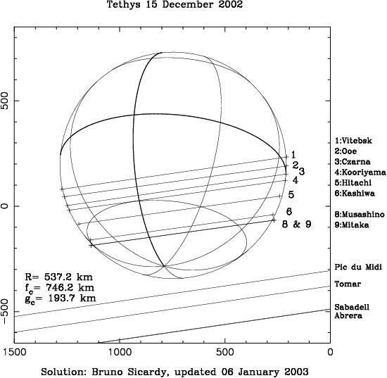
In order to obtain the graph above, I have allowed for offsets in time (Dt) at each station, choosing the Vitebsk timing as a reference. This is arbitratry , in the absence of criterium (at the present moment) to decide which station has the best absolute timing. Thus the Dt's listed in the table below could be changed by a constant arbitrary additive quantity, with the same conclusion as to the satellite shape.
With these offsets in time, I obtain a best circular fit to the chords with a radius of 537.2 km, and a rms radial dispersion of 6.0 km. The timing of chords 5-9 should be re-examined carefully to detect possible systematic trends in the corresponding timings, or even some interesting effects like the oblateness of Tethys.
The radius obtained here (537.2 km) is close to the equatorial radius of Tethys, as determined by Voyager :535 km.
Site |
Ingress (UT) |
Egress (UT) |
Dt (sec) |
Vitebsk |
19 01 25.41 |
19 02 05.82 |
+0.00 |
Ooe |
18 56 54.745 |
18 57 34.82 |
+0.28 |
Czarna |
19 01 41.0 |
19 02 20.35 |
-0.01 |
Kooriyama |
18 56 52. |
18 57 31 |
+0.66 |
Hitachi |
18 56 51.8 |
18 57 28.1 |
-0.54 |
Kashiwa |
18 56 50.6 |
18 57 23.61 |
+1.34 |
Musashino |
18 56 51.605 |
18 57 24.63 |
+0.52 |
Mitaka |
18 56 52. |
18 57 25. |
+0.12 |